Legal & Compliance
Even though I don’t know much about legal stuff, ChatGPT does, and I’ve done my best to make sure everything is correct and safe.
Before every flight, I make sure to:
Check the location to avoid restricted areas like airports, military zones, or protected nature areas
Fly only in legal and safe areas
Respect privacy rules and data protection laws — I do not record people or private property without permission, and I make sure that all footage is used only for the agreed purpose (like real estate listings or wedding videos)
Keep the drone within line of sight at all times
Avoid flying over crowds or in unsafe situations
Operate carefully to prevent accidents
I also make sure that any images or videos I capture are handled responsibly. Personal data is never shared without consent, and all footage is stored securely until delivered to you. This way, you can trust that your property, event, or memories are handled with care and respect.
All of our pilots are fully registered with AESA and operate in full compliance with current Spanish and EU drone regulations, ensuring every flight is conducted safely, legally, and professionally.
Even though I’m only 15, I take my work seriously. Every flight is planned and executed with safety, legality, and attention to privacy, so you can enjoy your aerial photos and videos without any worries. My goal is to give you amazing, professional shots while keeping everything fully legal and respectful.
Flying drones is my passion, and I want to help you see the world from a new perspective — safely, legally, and responsibly!
What you have to check before every flight.
Section A — OUTSIDE no-fly / prohibited zones
A1 — Under 250 g
A1.a — With camera
Operator registration: If the drone has a camera that can capture personal data you must register as an operator with AESA and mark the drone with the operator number. (EASA/AESA rule: <250 g without camera is exempt; with camera you generally must register.)
Pilot training/certificates: for many subcategory C0 legacy drones under 250 g you may not need the A1/A3 exam, but you must follow manufacturer instructions and the open-category rules (check AESA webpages for exact training required for your drone class).
Flight rules: VLOS, max 120 m AGL, don’t overfly people or assemblies, respect minimum lateral distances in urban/controlled areas, and obey any municipal or protected-area restrictions. Night flights: generally allowed for very light drones only under specific conditions — verify AESA limits.
Privacy: comply with Spanish data protection law (don’t capture people’s personal data without legal basis / consent). See AEPD guidance.
A1.b — Without camera
Operator registration: If the drone is <250 g AND has no camera/sensor capturing personal data, you generally do not need to register. Still follow open-category operational rules.
Flight rules: VLOS, max 120 m AGL, no overflight of crowds, respect local restrictions. No special privacy obligations related to imaging (still avoid invading privacy).
A2 — Over 250 g
(This typically moves you into different open-subcategories and can require AESA registration and at least the A1/A3 certificate or more depending on exact mass and CE class label.)
A2.a — With camera
Operator registration required (AESA). Most >250 g drones have cameras so assume registration is required and put the operator number on the aircraft.
Pilot training: you will generally need the A1/A3 certificate as a minimum; for closer operations to people or urban areas you may need the A2 certificate (see AESA guidance for subcategory and proximity rules).
Flight rules: VLOS, max 120 m AGL (unless specific authorization), do not fly over people / crowds, respect lateral separation rules (A2 allows closer to people with A2 certificate but observe separation minima), and check local protected areas (parks, ZEPA, national parks). Insurance is strongly recommended / may be required.
Privacy/data protection: same obligations, plus likely higher scrutiny for commercial use. AEPD guidance applies.
A2.b — Without camera
Operator registration: if >250 g, registration is typically required even if no camera — check AESA registration page. (Rule: mass thresholds and sensors both trigger registration obligations.)
Flight & training: same VLOS / 120 m / certificate requirements as A2.a depending on subcategory and intended operation.
Section B — INSIDE no-fly / RESTRICTED / PROHIBITED zones
B1 — Under 250 g
B1.a — With camera
Red (prohibited) zones: you generally may NOT fly even if under 250 g unless you obtain an explicit written authorization from the authority indicated in the map pop-up (ENAIRE, Ministry of Defence, park manager, etc.). Some prohibited zones are never authorised for civil flights. If an authorisation is available you must follow its conditions (safety buffer, NOTAM, insurance, operations plan).
Orange / Danger areas: you may be able to fly only after coordination and only when the danger area is inactive or conditions are met — check schedule/NOTAM.
Operator registration & privacy: still applies (camera = AESA registration if personal data capture possible).
B1.b — Without camera
Red zones: same — not allowed without specific written authorisation from the responsible authority. Even if <250 g and no camera, red areas are controlled by airspace rules (national security / safety).
Orange/danger: check activation times and coordinate.
B2 — Over 250 g
B2.a — With camera
Red zones: almost always require formal written authorization (ENAIRE or Ministry of Defence) — approvals are conditional, often require a detailed operations plan, insurance, and time to process. Many red military or protected zones will not grant permissions for civil flights. Do not assume a permit will be granted.
Orange/danger: may be permitted with coordination, temporary NOTAM deactivation, or other conditions — you must follow instructions and get written confirmation.
B2.b — Without camera
Same as B2.a for airspace permission: weight does not let you bypass the airspace restriction. If the zone is controlled/prohibited you need the same formal processes.
The information provided above is for general informational purposes only and is based on publicly available regulations and guidance at the time of writing. Aviation and drone regulations may change, may be interpreted differently by authorities, or may depend on specific local conditions and authorisations. No guarantee is given regarding the completeness, accuracy, or current validity of this information. The author accepts no liability for any errors, omissions, or consequences arising from the use of this information.
All users are solely responsible for verifying current rules, airspace restrictions, and permissions directly on the official ENAIRE Drones website and with the relevant authorities before flying.
How to use the ENAIRE Drones map
Open the ENAIRE Drones map
Click the button above to open the official ENAIRE Drones airspace map for Spain.
Find your location
Use the search bar or zoom in on the map to locate the exact area where you plan to fly.
Enable the map layers
Open the layers/legend menu to display no-fly zones, restricted airspace, and other relevant areas.
Click on the area you want to fly in
Click directly on the map. A pop-up will show whether flying is allowed, restricted, or prohibited, including height limits and permission requirements.
Check again before flying
Always re-check the map on the day of your flight, as restrictions and NOTAMs can change at any time.
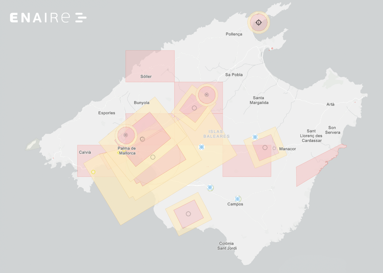
Mallorcas main No-FlyZones and restrictions:
Red areas on the ENAIRE/official drone map indicate prohibited / no-flight zones or highly restricted controlled airspace where you must not fly unless you have explicit authorization from the competent authority
Orange (and similar amber/yellow) areas are typically danger / caution / restricted zones (for example: Danger Areas (D) or controlled airspace buffers) where hazardous activities may occur at certain times or where limited operations are permitted subject to conditions (check exact layer details).